Wednesday, June 20, 2012

Legend of the Falls.. The Lesmurdie Dip!

 We were on our back from Mt Dale when I realized a familiar road we were passing. It was near a bushwalk I've done last year; near the Lesmurdie falls.Quickly, I asked Syafiq to reconfigure the GPS to see where we are and is the falls nearby.. and Walah.. it was just 3km away from where we were! Alhamdulillah.. it was a perfect spot for us to perform Zuhr. However, the GPS brought us to another starting site which i never knew about. It was near to the foot of the falls when last year , I walked from the top of the falls. Upon looking at the signage.. waahh.. less than a km away from our parking spot.
 The falls was certainly amazing! I saw it late Spring towards summer therefore the flow of water was much less. Now in mid winter, it was flowing to its strength and with Perth having one of their rare really wet winters.. it certainly made the waterfalls to function at its maximum! Subhanallah..
And.. since we had a go at the previous falls, WHY NOT again? hahaha Why not..why not... such a powerful motivational term theme I've been influenced by in the past few months!


 It was cold I must say.. (haha.. abistu dah winter..takkan panas kot?) but maybe not as cold as EMES falls. We were blessed with the clear skies that we suddenly had and it became one of my best moment in Perth outdoors so far! I am glad i did not chicken out and just did it! Alhamdulillah.. it was such an amazing feeling being one with nature :)
We may be a bit crazy but not that crazy to spend that much time in the cold freezing water. It was just good enough to enjoy it for a while, had a feel and suddenly it was not cold anymore! We are invincible! hahaha Alhamdulillah, the trek trip we had was certainly good and god work in mysterious ways.. There maybe reason why we did not reach Beraking and to finish the day with another waterfall dip.. was PRICELESS :)

Wet Mount Dale trek

 I'm not sure whether it was a rush, but there was this sudden urge to do bush walks more in the winter. When Syafiq texted me saying he has transport for the week, the thought of Mount Dale came into mind. Mt Dale is the 2nd highest peak around Perth and by doing this walk I would be completing my aim to conquer the peaks around Perth; eventhough its not that high relatively. I had a long look at the WalkGPS website and put my mind to it, it is somewhere we just had to go to!
According to the notes, 70% of the walk is off track and little that we know how off track it can really be! It was perhaps the toughest trail we had so far; i reckon because the trail was almost non existent as compared to the tracks we have followed in our earlier hikes.The weather forecast was not promising and again, it became a big factor for us!
 Syafiq picked me up at Cannington train station ( well.. i walked a bit to a nearby Superstore) and little did I know we had 2 new members. Both were Syafiq's friends and relatively new to bushwalking. Haha Of all my trips, they just had to start off by following a potentially difficult trek! haha The route to Mount Dale parking area was on ungraveled road; making only SUVs to be appropriate for the 16km to the starting point!
The aim of our walk was to reach Beraking Brook which is about 6km away. Of course again, the rain greeted us on its heaviest when we were about to start the walk.It was really really heavy! Basah kuyup tu.. hahaha

 Despite the GPS coordinates that we had, we tried as much as possible to look for possible tracks as from our previous treks, there is a clear track somewhere. It did not happen on this one, We diverted and diverted.. and honestly the map that showed up on Syafiq's GPS showed a spider web configuration! Of course the weather was permitting with the thick fog and as wet as you can be in the bush! Dahlah sejuk! hahahaa It was certainly different being in the bush while raining. When the cloud cleared up with the sudden sun ray coming true, the landscape changed and it was just breath taking to be up there. However, it was temporary and the aura changed dramatically.


 We managed to reach a nearby point; and that was only when we decided maybe we should just go into vector line trek. Which means that nothing can stop your way! Macam steam roll!! We cant use parangs like we do in Malaysia to cler the track because of the regulations of Aussie forest.I really tested my gear today for waterproof and durability! Haha kalau pakai kain cokia confirm dah lama koyak but somehow the rainjacket maintained its integrity despite my violent nature going through the thick sharp bushes. I'm sure the new trekkers had few bumps, scratches here and there but I guess thats their introduction to bushwalking the hard way in WA!


 We reached the Rocks at noon and if we were to follow the map and coordinates, the ETA to the brooks would be 3pm and the walk back to the starting point would be in the dark. Of course, we were not prepared to hike in the dark therefore it was decided for us to turn back due to safety issues. It would not be nice if the 4 of us to appear in the Perth news for Search and Rescue effort! hahahaha


 We reached the starting point quite swiftly.. due to the "vector" nature of the hike back and meeting up with the Mount Dale track. At the parking point, when the clouds were clear.. Subhanallah, the beauty of Allah's creation was obvious and we did enjoy the sight which was visible to us. After a quick lunch, we were back on the SUV on our way back home. I did enjoy the trek, it was a definite first on one of the difficult ones and I would like very much to take the challenge again..but of course, on a day where the weather was better!

Mandurah wet visit

 I planned the Saturday for a long ride to Joondalup. The unexpected rain certainly dashed my hopes but that morning I was ready to go somewhere. Therefore, I decided to visit Mandurah - 70km away from Perth.
It used to be a small fishing town and currently is being developed as a tourist attraction. Most of the tours offered on seeing/touching/swimming with dolphins and sea lions would depart from this port. Apparently you would not be dissappointed with their cruises.

 I did not plan to take the cruise as yet for I may want to board it with my parents or family members when they come to Perth again. I did not do anything much, just walked on the foreshores , planks and of course the New Venice which was certainly well done! I do hope to own one of those one day.. haha Otherwise, it was a light and easy solo trip topped up with a Cicerrello's seafood lunch :)

Sunday, June 17, 2012

Mt Mambup,Bell's rapid and EMES falls hike

 I had planned this trip with GEBU in April - a day before I left for Malaysia. However it never materialised because of few issues and I had to get something for home that Saturday. After coming back from Melbourne, I had another day off and i figured out that I should do something interesting. Contacted Syafiq as i knew he was done with the exams and its the Semester holidays at the moment.
 The only main issue is neither of us had transport and we had to go on the public transport. The only drawback to that the starting point is 2.1km away from the last bus stop which is along Northern highway just before Copley Road. I knew, it is only with Syafiq that I will be comfortable doing this hike as i can gauge his abilities after the few that we have done together.I have to give credit to the website walkgps as without it, I could not have done the few walks that I've done- as the information, the map and the GPS coordinate is certainly very-very crucial to the success of the walks! Thanks again! 
 The climb to the summit of Mt Mambup was a bit of a challenge as the hike up was straight up.. We started off from about 20m above sea level, having to reach the summit of 220m! haha There was a bit of huff and puff but it was what we wanted anyway. The weather was definitely getting better as the predicted rain did not really make its appearance in the Swan Valley.
What made the trek up to the summit interesting was the number of wild kangaroos that we met along the trek. I did felt like somebody was watching us and when we stopped and lookd around.. Alas! There were few kangaroos looking at us from a far. We tried to take some photos by moving to them but unfortunately the movement and of course, a phone call i received made them run away!
                                                  Spot the 3 of us :)
                                                  Useful map and coordinates
                                                 Arwah kangaroo on track
 The descend down was good and we were to arrive at Bell's Rapid. Coming in winter is definitely a must as the river swan is filled up well especially a record of rainfall last month and this on going winter.It was definitely National Geographic stuff watching the rapids and being there was just Subhanallah.. This is why I like being in WA!

 Based on the information given as well as the map track, we went looking for what was called the unnamed falls. Apparently the falls is only obvious during winter months and it is an opportunity which we would not want to let go. The trek to the falls can be challenging at times, having to climb above and by the side of the rough rocks - but arriving at the falls was definitely a heavenful feeling ! Berbaloi and memang cantik!
We were already there.. and it was really beautiful. The sound of the falls hitting the ground was simply amazing.. It was in the middle of winter, it was cold.. and like a true JACKASS movie scene, both of us had a go to enjoy the waterfall! Hahaha Gile psycho.. It was damn cold..but it was worth the fun and of course, the action! Sapa pernah buat bro? hahaha Pyscho hanya sekali!!
I am certainly glad i made the trip. I must thank Syafiq for being a good companion and partner - especially during the times when we discovered that we maybe off track! hahaha Honestly, Eventhough the bush maybe well marked, one needs the coordinate to confirm one's position and not assume the trail on the map is the main track on the ground!

Mt St Gwinear hike - first snow climb:)

13 June 2012; Shakti and I last climbed a summit together in 2005 - and that was Kinabalu. We went to Lolo but not to the peak of Nuang soon after that. And my presence in Melbourne certainly spurred Shakti to have a go at a moderate summit climb. I was initially worried that it might not happen ; as when winter comes, then the trek will be closed for ski cross country. Neither of us hesitated, so we undertook the 200+km site from Melbourne early that morning. Mt St Gwinear is near enough to Mt Erica, which is the 1st summit in the long 650km Australian Alpine trail - which would end in Kosziousko which is the highest summit in Australia.
We had to turn back at this point because we did not have a chain with us. Apparently, in winter we are supposed to have this with us if we are on this trail. The rent is AUS15 but if you're caught without one you'll be fined AUS400! You want to play safe when you're in Aussie as I'm sure those with my luck will definitely kena la kalau tak buat! We 
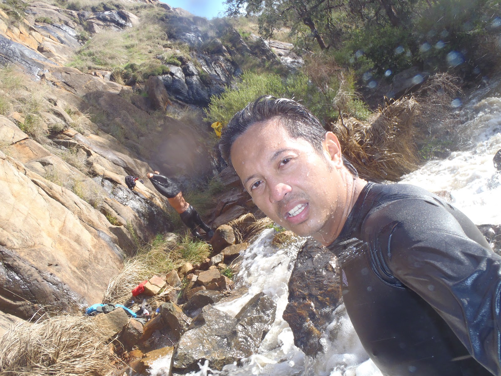
were not sure if we were able to be on the summit hike, as officially in winter it is closed! However, due to the non-existence of snow in the earlier part of the track, we just had to SONDOL! I mean, I've come far enough to not step and be on top of Mt Gwinear!
The hike was 3 km to the top - we were at about 1100m at the carpark so the elevation climb was 400m up.Of course, as we reached 1/3 of the way the pathway was beginning to be covered with snow! And not the wet type but hard one! Yaaahh.. this is definitely my 1st hike in the snow! It was not that difficult when the snow was not that thick but as we went higher.. hmmm.. a bit difficult to walk when the snow is not tat hard.
                                                           Gambar Golden Dream! hahaha
I must say the view was definitely out of the world. I was enjoying the hike so much that i may have went ahead to fast for my dear friend. Shakti was a bit puffed as this was his first outdoor hike in quite sometime, perhaps even for a cardio workout!
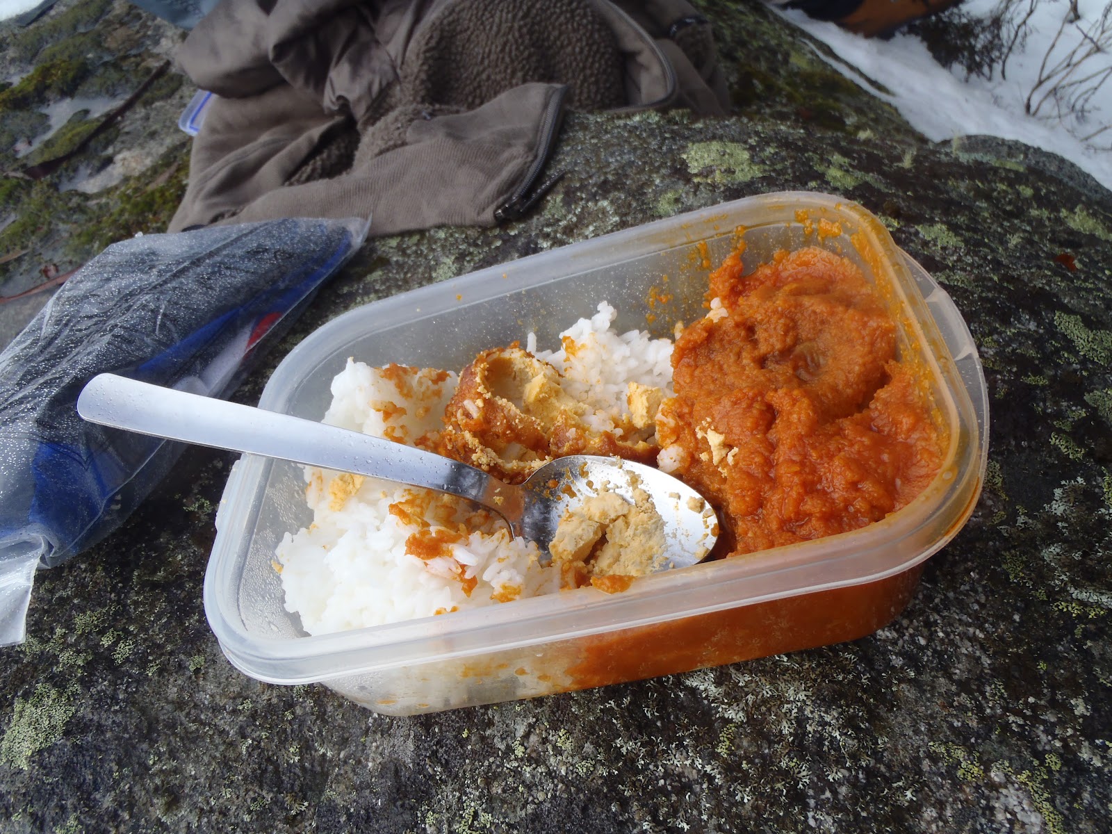
We reached the top by noon.. and what a feeling to be at the summit. 1509m :) Mt St Gwinear and yeehaaaa.. Alhamdulillah! We took some pictures, i had a piss (haha) and had some lunch. It was really cold when i had my hands bare - where it literally froze as i was not able to finish the packed nasi telur merah that we had! hahaha
It was a lucky day for me as well as i managed to sight a big Deer who sort of spied on our presence at the summit. It was really big and looked like a reindeer. Of course, when i spotted it, she ran off and only then i did appreciate her size. Gile besar!
                                                      Summit Mt St Gwinear 1509m
                                                            cant finish it..too cold!
Alhamdulillah, we managed to descend safely to the carpark. It was definitely an enjoyable climb and if we came earlier, we would have gone on the traverse hike to Mt Baw Baw which was 3km away from the summit across te range. However, considering our unpreparedness it would not have been a good idea to continue SONDOL.. hahaha
We managed to drop to a couple's place in Dandenong; both were my colleagues in UiTM. Thanx Azrina for the lovely mee goreng which was tasteful after the cold climb we had earlier that day!